• Sign in
  • |
  • Home
  • Layers
  • Maps
  • Documents
  • People
  • Search
  • Dewetra Layers
  • facebook
  • twitter
  • google+
  • Explore Maps
Create a New Map

Explore Maps

  • Most recent
  • Less recent
  • A - Z
  • Z - A
  • Most popular
  • Relevance
View by Grid List

Your selections Clear all

Extent

Categories

  • All Categories
  • biota 0
  • Biota 0
  • boundaries 0
  • Boundaries 0
  • Climatology Meteorology Atmosphere 0
  • Economy 0
  • Elevation 0
  • environment 0
  • Environment 1
  • Farming 0
  • Geoscientific Information 0
  • Health 0
  • imageryBaseMapsEarthCover 0
  • Imagery Base Maps Earth Cover 0
  • inlandWaters 0
  • Inland Waters 0
  • Intelligence Military 0
  • Location 0
  • Oceans 0
  • Planning Cadastre 0
  • society 0
  • Society 0
  • Structure 0
  • Transportation 0
  • Utilities Communication 0

Date

Keywords

Total: 10

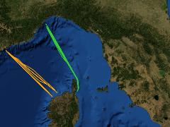
Cetacean surveys aboard ferries on the routes monitored by CIMA Research Foundation in 2015

Map from BIO, 9 years, 6 months ago

Cetacean surveys aboard ferry on the routes monitored in 2015. Data are collected for the Monitoring Network aboard ferry, coordinated by ISPRA (Italy).

  • 1507 views
  • Average rating (0 votes)

Download View

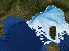
Pleasure vessel density from AIS

Map from BIO, 10 years, 2 months ago

  • 1283 views
  • Average rating (0 votes)

Download View

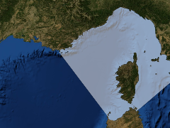
Pelagos Sanctuary Area [Fondazione CIMA, 2014]

Map from BIO, 10 years, 9 months ago

  • 1505 views
  • Average rating (0 votes)

Download View

Municipality partners to Pelagos Charter (August 2014)

Map from BIO, 10 years, 9 months ago

  • 903 views
  • Average rating (0 votes)

Download View

results 5-8 of 10
  • Previous
  • page 2 of 3
  • Next
Powered by GeoNode version 2.0.1 | Developers | About